Got up at the usual time and found that it was raining, just like the day before. The forecast for central Utah called for showers, so I dressed for a rain day. Took my own advise from yesterday and dressed slowly. Worked much better. By the time I was ready to leave, I was warm and dry and ready for nature’s worst. But nature has a sense of humor…it stopped raining right when I left to hotel.
I dropped by a Best Buy and bought some recordable DVDs so that I could archive some of the video that I have been shooting, but not editing and posting. The hard drive partition that I had set aside was already full.
Headed south to Provo. Rode past BYU. Nice campus. South of Provo, the highway heads towards Moab, Hwy 6 and others, goes up over a mountain pass and then down into central Utah. The rain the day before had dusted the mountaintops with snow, but it was still pretty cloudy so visibility was spotty. At the entrance to the pass, there is a phalanx of power-generating windmills, just like I had seen from afar on in the Columbia Gorge. The road went right past these, and boy are they big! Couple of hundred feet high I’d guess.
The highway drops down out of the mountains and into a little mining town called Helper. I took the cutoff and drove though the town just for kicks. It was kind of sad to see. Mining had declined considerably in that area, and the town of Helper, which obviously had been quite the place in its heyday, was clearly dying.
Continuing on, the highway heads out onto a plateau. I gassed up in the town of Wellington. Just outside Wellington, right in the middle of passing a big, gas-guzzling RV, the engine died. I pulled over to the side of the road, praying that the problem was a loose spark plug wire. Unloaded everything to get to the engine compartment, peaked in and sure enough, there was the spark plug wire dangling loose. So I stuck my hand down there to put it back and—YEOUCH!—got burned by the hot engine…duh! So I had to wait about 15 minutes for it to cool down enough to put the cap back on. Then I was back on my way.
As an aside, there I was, out in the middle of nowhere, with all the stuff off of my bike, and my head stuck down in the engine compartment, for about 15-20 minutes. At least 50 cars and trucks went by during that time, and NOT ONE stopped to see if I was okay or needed any help. That’s comforting.
By this time, the sun had broken out and the clouds were clearly dispersing, so I got out the video camera and started recording again. I had dodged showers throughout the day so far, but it looked like it was clearing up for good. Continuing on, there is a pretty dramatic-looking mountain range that parallels the highway on the left. Not sure what its called, but it had a couple of peaks that would have made really good lookout positions.
BTW, all during the section of the ride, I kept thinking about the old westerns that I had seen, and thinking that all these canyons that I was riding through would have made really good ambush points, and that these mesas would have made really good lookout positions. When you see these places on film, they look flat. But when you seen them in person, you get a real sense for how the Indian wars would have played out.
When you round the southern end of the range, the highway meets up with Interstate 70 in a town called Green River. It was there that I noticed a rather large rain cloud away to the south that was moving west to east like I was. It was headed right for Moab just like I was. The race was on!
I-70 was practically deserted, so I made pretty good time to Crescent Junction where Hwy 191 branches off toward Moab. As you approach Moab, the road starts to descend into a canyon. Off to the left, I could see this really dramatic-looking red rock formation, which I learned later was the Devil’s Garden area of Arches National Park. Off to my right, that big rain cloud was getting closer.
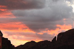
I pulled into Moab at the bottom of the canyon, cruised up and down the strip once or twice, and found a nice motel. I checked in and got all my stuff off the bike. By that time, the sun had just gone down behind the canyon walls, and the rain storm was approaching. I took a couple of really cool pictures of the storm as it approached, which I’ll post soon (yeah, right). It rained for about and hour, and then it stopped and started drying out.

Went to a local cafe for dinner, and had a Scorpion Ale. Pretty good, but not as good as Polygamy Porter (“Why have only one?”). The plan for tomorrow—get up early and head into Arches!
This is fun to hear about–we went through this area on our drive back from Austin in June, and stayed a few days in Arches. I thought it was one of the most beautiful landscapes I’d ever seen–truly stunning! Sounds like we ate at the same cafe, and sampled the same beer. Hope the mosquitos weren’t terrible (they were fierce when we were there).