Leaving Cortez just after 9am, there were two destinations on the agenda for today. First was Four Corners Monument and second was Monument Valley. The only real decision was whether to drive through Monument Valley from south-to-north, or from north-to-south. The main consequence was which town I would be spending the night in. After consulting with one of the Navajo jewelry vendors at Four Corners, I decided on north-to-south, spending the night in Kayenta, AZ, or “K-Town” as the Navajo call it.
Four Corners Monument
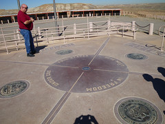
The is the place—the only place in the USA, actually—were 4 states all come together and meet at a single point. This happens due to the fact that the borders of all four states are straight lines and cross in an “+” pattern. The states are, in clockwise order starting in the upper left, Utah, Colorado, New Mexico and Arizona. Hwy 160 comes in from Colorado on a NE-SW line, clips across the extreme NW corner of New Mexico for no more than a mile, then continues on into Arizona. Right in the middle of the New Mexico segment, an access road leaves the highway and runs to the NW for about a quarter-mile to the monument itself.
The monument is on Navajo land, so they own and operate the park. There is a nominal fee to get in. Right at the point where the four state’s borders meet is a raised platform surrounded by the state’s flags and seals, and right in the center of the platform is a small brass plaque set in the ground marking the exact point where the four states meet. Off to one side is a raised wooden platform where one can take photographs of one’s friends and/or relatives sitting, standing, kneeling, squatting or doing something else in all four states at once. I only took 3 pictures here; there just isn’t that much to see. Surrounding the platform is a gravel parking lot, and surrounding the parking lot is a ring of booths where Native American vendors sell various arts and crafts and foods. Kind of like Saturday Market only all in a big circle out in the middle of nowhere. I bought a bunch of souvenirs here, so if you receive one from me, well, I hope you like it.
Monument Valley

Based on the advice of one of the Navajo vendors at Four Corners, I decided to loop around and come into Monument Valley from the North. I headed for the northern end of Hwy 163 and the little town of Mexican Hat. This town is named after a balanced rock formation north of town, which looks like a head wearing a sombrero. The town itself is a small, dusty place with a couple of motels and a cafe. I stopped there for lunch, and had an order of chicken stripes which was the worst that I’ve ever hand.
Leaving Mexican Hat, its about 10 miles until you get to Monument Valley. You can see the buttes in the distance as you’re driving, which looks kind of cool. I was on the lookout for this one particular stretch of the highway which you see a lot in movies and on TV. Here’s picture of it that somebody else took which you’ll probably recognize right away. Anyway, as I drove over it, I didn’t recognize it. I was looking for something much more grand. It turns out that I did actually get a picture of the road, but it was totally by accident because I had stopped to get a shot of the monuments in the distance. Its just another example of how film, both still pictures as well as movies and videos, really don’t present an accurate portrayal of real places.
As I rode into the place on the map called “Monument Valley,” I learned that there are really two Monument Valleys. The first is the big area called Monument Valley, which includes a town, a high schools, a resort motel, gas stations, homes, scattered ranches, and so on. Pretty much everything you would expect in and around a normal dot-on-the-map town. This area also contains lots of buttes and mesas that are beautiful and photogenic. But the Monument Valley of film fame is located off to one side of the main valley, and is contained within the boundaries of the Monument Valley Navajo Tribal Park. This is pretty similar to a normal U.S. National Park, only its run by the Navajo Nation instead of the U.S. government. There’s an entrance fee. and a visitor’s center, and concessionaires selling tours and trinkets.
The main attraction is a drive through the valley itself, which is a 17-mile loop road going past all of the famous landmarks that you’ve seen on film and television. The unfortunate thing for me is that the loop road is unpaved, and the Vespa is not an offroad vehicle! But, I gave it a try anyway. The first part of the road was pretty smooth. Just packed dirt and an occasional rocky patch that I could easily ride around. After a little ways in though, it got rougher and rougher. Nothing a normal car couldn’t handle, but it sure bounced me around quite a bit. I was sure that things were going to start falling off my scooter, but it actually held together pretty well.
I ended up going in about 4 miles to John Ford’s Point, then I decided to turn around and come back, mainly because it was getting dark and it would be hard to see all the bumps in the road on the way back. I ended up seeing most of the recognizable landmarks. I’ve never seen the John Wayne movie The Searchers, in which John Ford’s Point figures prominently, so I’ll have to rent that when I get back. The only thing that I didn’t see that I had wanted to was The Totem Pole, which Clint Eastwood and George Kennedy—or their stunt doubles— climbed in the movie The Eigar Sanction.
By the time that I got back to the visitor’s center, it was dusk. I got back on Hwy 163 and headed out south. If there was anything interesting to see in the south part of the big Monument Valley, I didn’t see it because it was dark. According to the maps, I don’t think that there was. After about 20 miles or so, I entered the town of Kayenta and spent the night at a ridiculously overpriced Holiday Inn.
Hey – did you hear of Hovenweep? It is rather plain, but quite enchanging. rena